
 Image 1 of 1
WALK DETAILS
Meeting Point: CRiC NP8 1BN (for bus to start)
Grid Ref: SO 218184
What3Words: breaches.inflating.upset
Time: 17:00 to 23:00
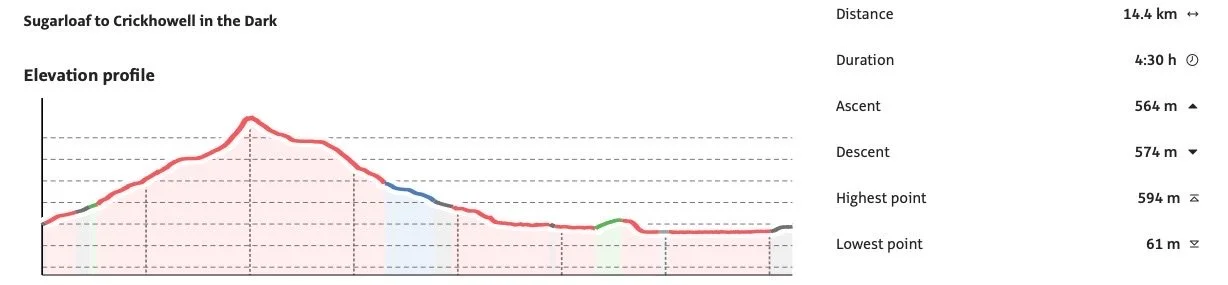
Distance: 10 miles ( 16.0 km )
Ascent: 2200 ft ( 671 m )
Leader: Paul Sheffield
We take a minibus to Abergavenny then walk steadily up Sugar Loaf via Llwyn Du and an old quarry path. We pause in full darkness at the top of Sugar Loaf then walk down the western ridge passing Pengilfach farm and Ty Canol, then on down to the Grwyne Fawr river. We follow the river to Llangenny Bridge and Millbrook Bridge before taking the path through Rheld Wood to reach the main road and River Usk beyond. We walk beside the river and up Bridge Street to the centre of Crickhowell. A waning crescent moon won't help us so a head torch and warm clothes are essential
DIRECTIONS TO START
CRiC - the Crickhowell Resource and Information Centre - is situated on the A40 in the centre of Crickhowell. The post code is NP8 1BN.There is a public Pay and Display car park immediately behind the CRiC building which is accessed from Greenhill Way by the Fire Station. At the weekends a voluntary donation allows you to use the School Car Park. Continue along the A40 to the Asda Petrol Station. Turn left and the school is on your right.