
 Image 1 of 1
WALK DETAILS
Meeting Point: CRiC NP8 1BN
Grid Ref: SO 218184
What3Words: breaches.inflating.upset
Time: 10:00 to 15:00
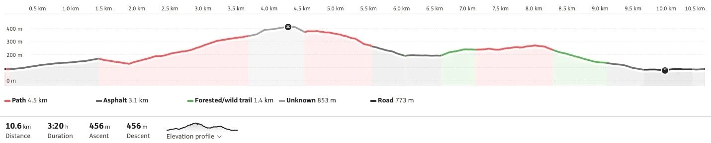
Distance: 6.5 miles ( 10.5 km )
Ascent: 1660 ft ( 506 m )
Leader: Mark Davis & Emma Harrison
The walk starts at the CRiC centre and proceeds uphill along Great Oak Road, picking up rocky and uneven tracks leading to Cumbeth Brook. It is a continual ascent to a reach a lofty sheepfold. Turning west on rough and stony sheep tracks, the route contours to connect with the Beacons Way and an eventual steep descent to Cwm Mawr. We will then follow quiet lanes until the route turns off up a farm track. This leads to a faint path across fields and through woodland to reach a former farm settlement at Twyn. A good track and then a quiet road leads down past Gwernvale Farm to the main road and back to CRiC. Clusters of Scots pines were used as drovers' signposts — this walk links clusters of Scots pines and other features that indicate possible droving routes, and where drovers may have spent the night on their epic journeys to seek out the best prices at English markets for their Welsh livestock.
DIRECTIONS TO START
CRiC - the Crickhowell Resource and Information Centre - is situated on the A40 in the centre of Crickhowell. The post code is NP8 1BN.There is a public Pay and Display car park immediately behind the CRiC building which is accessed from Greenhill Way by the Fire Station. At the weekends a voluntary donation allows you to use the School Car Park. Continue along the A40 to the Asda Petrol Station. Turn left and the school is on your right.